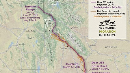
In the spring of 2016, a determined mule deer did something that, as far as anyone knows, no other mule deer had done before: She traveled a whopping 242 miles from southwest Wyoming to eastern Idaho in the greatest migration in recorded mule deer history.
A team of UO geographers has produced an innovative documentation of her feat so people actually do know about this impressive trek, which she’s repeated every subsequent spring, stunning the researchers tracking her journeys with a GPS collar. They hope their visualization will raise awareness about the critical migration corridor she followed and share the importance of preserving it for future generations of mule deer on the move.

“Her knowledge of such a vast migration route is amazing,” said Jim Meacham, director of the InfoGraphics lab and an award-winning cartographer. “In all likelihood, she learned this route from her mother, who inherited it from past generations of deer that optimized their migrations to exploit the resources of the landscape — and survived because of it. We hope this video helps make people and policymakers aware of the importance of preserving these big game corridors.”
The animal, known as Deer 255, surprised scientists when they witnessed her massive migration with the help of a GPS collar that tracked her movements from the deserts of Wyoming to the forests of Idaho. The mule deer is a well-studied mammal and biologists had never known of one to hoof it further than 150 miles in its annual quest for food after winter leaves animals undernourished, a phenomenon known as “surfing the green wave” where hungry animals chase the vegetation that sprouts after the snow melts.
When Deer 255 surpassed that distance by nearly 100 miles, she stunned the biologists tracking her migration, especially because it’s a journey riddled with hurdles. Traveling 242 miles by foot — or hoof — is not an easy feat in and of itself, but it’s particularly challenging when facing obstacles like busy highways, barbed wire fences and surging rivers.
The video includes footage of deer facing many of those challenges, along with some conservation solutions that make their journey an easier one, like highway overpasses, land easements and fencing that allows safe passage.
The video is part of an ongoing partnership between the UO InfoGraphics lab and the group of biologists from the University of Wyoming who study the migratory patterns of hoofed mammals, also known as ungulates, and share their findings with the public. The teams also collaborated on publishing “Wild Migrations: Atlas of Wyoming’s Ungulates,” which uses maps, photographs and text to share stories and insights about migrations around Wyoming.
“This project is an exciting convergence of spatial data and scientific discovery, animated in 3D,” Meacham said. “It helps identify ways to reduce mule deer mortality and protect this corridor.”
The UO’s Joanna Merson spearheaded the production of the 3D video, which incorporates cutting edge cartography, footage from the field and photographs to share the story of Deer 255 and track her 56-day migration this past spring.
“We wanted to communicate what it looks like to move through this landscape as a mule deer,” Merson said. “Our goal was to walk the viewer through a complex story and tell it in a clear and compelling way.”
With more than 1.2 million views, 5,000 likes and 700 comments cheering on Deer 255 as she migrates across an animated landscape, the group believes the public is finding the video engaging and gaining some insights into mule deer migration and the initiatives that help them cross such a rugged landscape.
While the video may be easy for people to watch, it was not a simple task to create. Merson spent countless hours and many late nights toiling over the intensive design process. It required processing volumes of GPS data to create the maps and considering a multitude of details, like colors of highways, mountains and rivers; fonts; camera speed and angle; and which features to include in each frame.
“I really wanted to give people a sense of place, so they could connect with the landscape and the mule deer,” Merson said.
She also used social media to share weekly maps she created to track Deer 255’s progress from late April to June during her migration this spring, a journey that once again surprised scientists as she stopped after 200 miles, possibly to give birth. Merson saw a lot of public engagement, both in reaction to her weekly tweets and to the video posted this summer.
“Our collaborative work with the Wyoming Migration Initiative is reaching a broad audience and really is having an impact,” Meacham said. “Mile by mile, Deer 255 is showing people the challenge and promise of conserving migration corridors in the American West.”
—By Emily Halnon, University Communications

